


TORONTO, ON / ACCESSWIRE / November 5, 2018 / California Gold Mining Inc. ("California Gold" or the "Company") (TSX-V: CGM, OTCQX: CFGMF) announces new assay results from the ongoing resource drilling program at the Queen Specimen zone at its flagship Fremont Property (the "Property" or "Fremont") in Mariposa County, California. Assays for the previously drilled holes from the current program at Queen Specimen were announced in separate press releases dated February 8, 2018, February 21, 2018, March 5, 2018, April 3, 2018, April 9, 2018 and May 2, 2018, respectively.
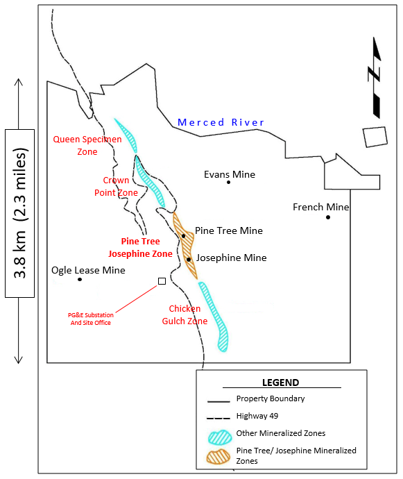
Today's results provide additional data in support of a second shallow mineral resource on the Property covering the newly identified Queen Specimen mineralized zone. This zone is located in the north-west portion of the Property, and constitutes roughly 750m of strike length, out of the total four kilometers strike of the Mother Lode shear zone (the "Shear Zone") on the Property.
Vishal Gupta, California Gold's President and CEO, said, "We continue to set new records for the highest grades ever received at the Queen Specimen zone through our current resource drilling campaign. The three holes released today were designed to test the continuity of the newly discovered high-grade mineralization hosted on the hanging wall side of the Shear Zone. All three holes unquestionably achieved their design objectives, and have now solidified the core of this high-grade mineralization within the Queen Specimen zone. It must be noted that all these holes are very shallow, with the deepest of them having a down hole depth of only 242.9m. Our next objective is to demonstrate the extent of this new discovery through along-strike step-out holes, while continuing to develop a substantial shallow mineral resource for the Queen Specimen zone."
Highlights from today's three holes at Queen Specimen are displayed in the following table. A map depicting the location of the major mineralized zones at Fremont, the plan-view collar locations for the three drill holes, and the corresponding geological cross-sections can be viewed in Appendices A, B and C, respectively.

Notes: Composite grades are length weighted to interval width. Composite true widths for QS-DD-18-019, QS-DD-18-020 and QS-DD-18-021 are approximately 77%, 64% and 87% of the reported intervals, respectively.
The Company's current NI 43-101 open pit-constrained mineral resource of 515,000 ounces grading 1.71 g/t gold in the Indicated category, and an additional 364,000 ounces grading 1.44 g/t gold in the Inferred category, only encompasses the Pine Tree-Josephine zone within the Property (the NI 43-101 Technical Report is available on SEDAR and at the Company's website www.caligold.com). The Pine Tree-Josephine zone hosts two historical underground gold mines, and covers a strike length of roughly one kilometre, out of a total strike of four kilometres over which the Shear Zone is interpreted to extend on the Property.
Discussion of the Queen Specimen Drill Holes
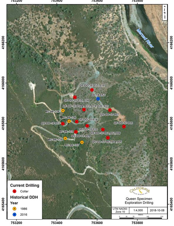
The three holes discussed in this press release were drilled as part of the resource drilling campaign at the Queen Specimen mineralized zone that commenced on December 2, 2017. The program is estimated to consist of 50 to 60 HQ-sized (2.5" diameter) diamond drill holes, totalling roughly 10,000m of drilling, with an average drill hole length of 180m.
The same lithological sequence was observed in these drill holes as with previously analyzed drill holes in the Queen Specimen deposit, and in the Pine Tree–Josephine deposit, including a sequence of metavolcanic mafic rocks overlying a melange of serpentinized ultramafic rocks. These are separated from the underlying meta-sedimentary rocks of the Mariposa Formation by a zone of highly sheared and serpentinized phyllonite that is characteristic of the Shear Zone.
In addition to the sequence stated above, a zone of fault-emplaced sediments is apparent within the hanging-wall mafic metavolcanic rocks. This stratigraphic repetition may be due to thrust faulting or folding associated with dextral movement along the Shear Zone that has been observed in airborne magnetic data acquired for the Fremont Project in 2016.
QS-DD-18-019
Drill hole QS-DD-18-019 was drilled at an azimuth of 245° and an inclination of -45° to a total depth of 237.7m.
This hole intersected two zones of mineralization from 62.8m to 65.8m, and from 138.5m to 143.7m depth. The average grades over these intervals are 0.62 g/t Au and 2.29 g/t Au, respectively. The mineralization is associated with structural melange with sericitic alteration. Mineralization was also associated with sediments and quartz veining with silicified dike inclusions. There is fine sulphide mineralization within the intervals.
QS-DD-18-020
Drill hole QS-DD-18-020 was drilled at an azimuth of 250° and an inclination of -64° to a total depth of 210.9m.
This hole intersected several zones of mineralization, most notably from 65.2m to 68.3m, and from 163.7 to 173.4m depth. The average grades over these intervals are 6.14 g/t Au and 1.25 g/t Au, respectively. The mineralization for the first interval is associated with talc-altered serpentinite. For the second interval, mineralization is associated with intermittent quartz veining, structural melange and sediments. There was sulphide mineralization noted within this interval.
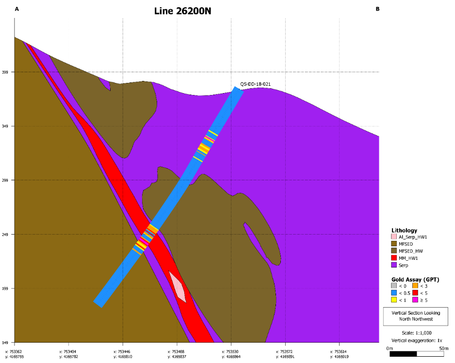
QS-DD-18-021
Drill hole QS-DD-18-021 was drilled at an azimuth of 215° and an inclination of -55° to a total depth of 242.9m.
This hole intersected significant mineralization across four separate intervals. The uppermost mineralized intersection occurs from 53.6m to 57.0m depth with an average grade of 10.64 g/t Au. This mineralization is associated with serpentinite-hosted pyritic sulphide. Visible gold was observed within this interval. The second mineralized intersection occurs from 61.9m to 71.0m depth with an average grade of 1.23 g/t Au. This mineralization is associated with serpentinite and structural melange. There is quartz veining present, as well as fuchsite and sericitic alteration within the melange. The third mineralized intersection occurs from 152.6m to 163.4m with an average grade of 1.56 g/t Au. The mineralization is associated with structural melange in contact with sediments. There is massive quartz veining and significant sulphide content. The fourth intersection occurs from 166.7m to 176.8m with an average grade of 1.14 g/t Au, and is associated with sericitized structural melange in contact with a brecciated mafic dyke. Sulphide mineralization is prevalent within this mineralized zone.
Application for Industrial Hemp Cultivation Submitted to Mariposa County
The Company also announces that it has submitted an application to Mariposa County seeking approval for the cultivation of industrial hemp on the Property. The proposed operations include the construction of a 20,000 sq ft greenhouse, to be primarily utilized for the propagation of industrial hemp seeds, along with the development of a 100-acre agricultural farm for the cultivation of an industrial hemp crop, and the construction of a 5,000 sq ft facility for the processing of the crop raw material.
At present, the Company is awaiting Mariposa County's approval before making a final decision on the industrial hemp cultivation operations. If and when the approval is granted, the Company will issue a subsequent press release announcing the approval as well as updates regarding any decisions to proceed with such cultivation operations.
Description of Quality Assurance & Quality Control (QA/QC) Procedures
The laboratory being used for assay analyses is American Assay Laboratories Inc. ("AAL") based in Sparks, Nevada (ISO/IEC 17025:2005 Certified).
Prior to transportation of core samples to AAL, all core processing is conducted at the project site in an enclosed 6,000 sq. ft. office facility. All diamond drill core is logged, photographed and split using core saws. Core from entire holes is being sampled every five feet to compare with the historic RC hole assay intervals. Additionally, sub-samples are being collected within the planned five foot intervals where important geological or mineralization contacts occur to allow better discrimination within the geological model. The minimum sample interval is 1.5 feet.
One half of the split core is transported to AAL by Company employees for prep and analysis. The other half of the core is stored at the Company core storage facility for future inspection and assay verification. All gold analyses of strongly mineralized samples utilize the screened metallics fire (SMF) assay method with a gravimetric finish. At the laboratory, the entire sample is crushed to 90 percent minus ten-mesh. A rotary splitter is used to obtain a 500 gram sample for pulverising. The screened metallics are collected as the plus fraction from a 150-mesh screen at the lab. The plus 150-mesh fraction is fire assayed in its entirety. Two separate one-assay ton fire (1ATF) analyses of the minus 150-mesh fraction are performed and arithmetically averaged. The minus and plus 150-mesh results are then combined for a total screened metallics fire assay.
A full QA/QC program, involving insertion of appropriate blanks and standards is being employed with acceptable results.
Mr. Vishal Gupta, the Company's President & CEO, has reviewed and approved this press release. Mr. Gupta is a P.Geo. registered with the Association of Professional Geoscientists of Ontario (APGO), and a Qualified Person (QP) as defined under National Instrument 43-101. The exploration program at Fremont is being conducted under Mr. Gupta's supervision.
About California Gold Mining Inc.
California Gold Mining Inc. is focused on developing its 100%-owned Fremont Project in Mariposa County, California. The project consists of an entirely private and patented land package totaling 3,351 acres of historically producing gold mines, with a state highway, PG&E electric substation and abundant water present on the Property itself. The Property lies within California's prolific Mother Lode Gold Belt that has produced over 50 million oz of gold historically. The Company purchased the Property in March 2013.
CAUTION REGARDING FORWARD-LOOKING INFORMATION
This California Gold news release contains statements that constitute "forward-looking statements". Such forward-looking statements involve known and unknown risks, uncertainties and other factors that may cause California Gold's actual results, performance or achievements, or developments in the industry to differ materially from the anticipated results, performance or achievements expressed or implied by such forward-looking statements. Such statements include statements regarding the potential industrial hemp operations. Forward-looking statements are not historical facts and are generally, but not always, identified by the words "expects", "plans", "anticipates", "believes", "intends", "estimates", "projects", "potential" and similar expressions, or that events or conditions "will", "would", "may", "could" or "should" occur. Forward-looking statements in this document include statements regarding planned exploration work on the Company's Fremont Property including the anticipated results and timing thereof. There can be no assurance that such statements will prove to be accurate. Actual results and future events could differ materially from those anticipated in such statements, and readers are cautioned not to place undue reliance on these forward looking statements. Any factor could cause actual results to differ materially from California Gold's expectations. California Gold undertakes no obligation to update these forward looking statements in case management's beliefs, estimates or opinions, or other factors, should change, unless otherwise required by law.
Neither the TSX Venture Exchange nor its Regulation Services Provider (as that term is defined in the policies of the TSX Venture Exchange) accepts responsibility for the adequacy or accuracy of this release.
For further information contact:
Vishal Gupta, President & CEO
Tel.: 647-977-9267 x333 | Website: www.caligold.ca
Appendix A
Map showing locations of the major mineralized zones on the Fremont Property
To view the full-size image, please click here.
Appendix B
Map showing locations of the three recently completed drill holes, along with previously completed exploration drill holes at Queen Specimen
To view the full-size image, please click here.
Appendix C
Geological cross-sections for the three recently completed Queen Specimen drill holes
QS-DD-18-019
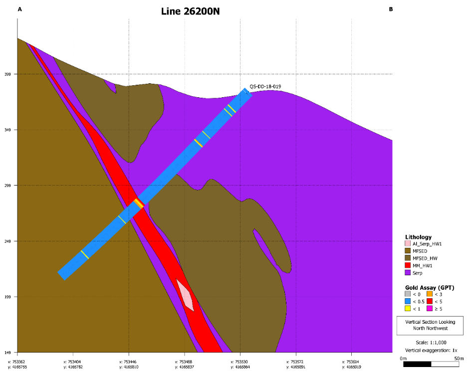
To view the full-size image, please click here.
QS-DD-18-020
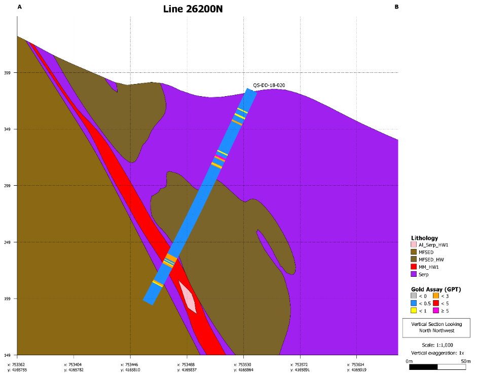
To view the full-size image, please click here.
QS-DD-18-021
To view the full-size image, please click here.
SOURCE: California Gold Mining Inc.
