


TMAC Resources Inc. (TSX: TMR) (“TMAC” or the “Company”) has received the results from the glacial till sampling program that was conducted as part of TMAC’s 2016 regional exploration program at Hope Bay. The results indicate multiple gold in till anomalies that are not well explained by the currently identified deposits.
This Smart News Release features multimedia. View the full release here: http://www.businesswire.com/news/home/20161222005814/en/
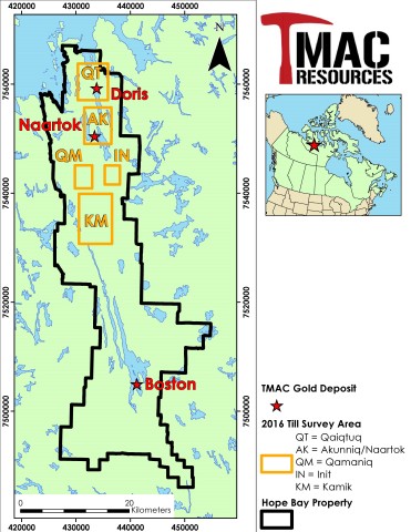
Figure 1: Location of the five till sampling grids completed at TMAC’s Hope Bay Project in 2016. (Graphic: Business Wire)
HIGHLIGHTS
The till sampling results have yielded the following significant dispersal trains:
- A prominent gold dispersal train approximately 4.5 kilometre long by one kilometre wide north-northwest of (or down-ice) from Naartok (which is located at the north end of the Madrid Trend) that may be representative of both Naartok gold mineralization and potential new gold target zones along the length of the dispersal train (the Akunniq exploration target area).
- Other gold dispersal areas south and southwest of the Madrid Trend (the Qamaniq exploration target area), and to the west and northwest of the Doris Mine (known as Qaiqtuq).
Dr. Catharine Farrow, Chief Executive Officer stated “We are excited by the excellent results of the 2016 glacial till sampling program at Hope Bay. TMAC has identified gold grain dispersal trains resulting in multiple exploration targets in close proximity to TMAC’s existing infrastructure at Doris, including targets along our existing road connecting Doris to North Madrid. These results will be integrated with TMAC’s existing geological and geophysical datasets and will be used to advance these and other target areas as part of TMAC’s 2017 exploration programs at Hope Bay. They also support the excellent exploration potential of TMAC’s land package in western Nunavut. We continue to develop a robust pipeline of exploration projects at various stages of advancement, from Mineral Resource addition within the known mine environments, such as Doris BTD, to regional exploration targeting as demonstrated by the results reported here.”
HOPE BAY 2016 TILL SAMPLING PROGRAM
In June and July of 2016, a total of 522 till samples were collected by Overburden Drilling Management Limited (“ODM”), well-known specialists in glacial till sampling, processing, and interpretation of surficial geological processes. The use of glacial till as a prospecting medium at Hope Bay has the potential to be highly effective because the till is derived from the erosion of bedrock during glaciation and thus may contain gold grains from any mineralized zones that were in contact with the ice sheet. Any available gold grains would be transported down-ice to form dispersal anomalies, or “trains”, oriented in the direction of ice flow, which at Hope Bay was north-northwest.
The generation and identification of the initial five target areas for the 2016 till sampling program was based on a detailed lithological/structural interpretation completed by TMAC on the Hope Bay Belt (Figure 1). This interpretation was based on: 1) the results of the high-resolution CGG HeliFALCON airborne gravity gradiometer (AGG) survey flown over the entire Hope Bay Greenstone Belt (12,676 line kilometres) in 2016; 2) the results of a high-resolution SKYTEM electromagnetic and magnetic survey flown over the Hope Bay Greenstone Belt (12,123 line kilometres) in 2015 and 2016; and, 3) an extensive compilation and interpretation of historical geoscience data including geological mapping and surface outcrop sampling.
The glacial till sampling program was designed to evaluate these five prospective regional target areas in the north and central portion of the Hope Bay Greenstone Belt with the objective of identifying gold grain dispersal trains indicative of significant undiscovered mineralization. In total, six gold grain dispersal trains and individual sample anomalies have been identified from the 2016 till sampling program demonstrating the prospectivity for significant gold mineralization outside of known deposits. The gold grain dispersal trains defined from the 2016 till sampling program are being integrated with TMAC’s geological and geophysical data to further refine specific targets to be evaluated as part of TMAC’s 2017 regional exploration program.
Till samples weighing approximately 10 kg were collected at approximately 300 metre intervals on lines spaced 500 metre apart and oriented perpendicular to the north-northwest direction of glaciation. To ensure an effective survey, the samples were collected selectively from frost boils in which till of the best quality was exposed. The samples were processed in Ottawa at ODM’s heavy mineral laboratory. The gold grains were extracted, and their dimensions measured and classified as “pristine”, “modified”, or “reshaped” to estimate the distance the gold grains travelled from their potential bedrock source(s).
RESULTS OF 2016 TILL SAMPLING PROGRAM
In general, gold grain counts ranged from 0-grains up to 1,196-grains per till sample for the 2016 survey. Based on the analysis of the distribution of gold grains collected in 2016, ODM determined the average background number of gold-grains in a 10 kg till sample for the Hope Bay Greenstone Belt was 12-grains, and the significant anomaly threshold was determined to be 35-grains per 10 kg till sample.
AKUNNIQ AND NAARTOK AREAS
The Akunniq exploration target area is located south of Doris Mine and north of the Naartok deposit, at the north end of the Madrid Trend. The geology of the area comprises a sequence of mafic volcanic flows, including high iron-titanium basalt and interbedded volcanoclastic rocks. A series of second- and third-order structures associated with the Hope Bay Deformation Zone (HBDZ) and the Madrid Deformation Zone (MDZ) crosscut stratigraphy at a high-angle as interpreted from the high resolution 2016 airborne gravity survey and based on the extent and orientation of overburden filled valleys (Figure 2). These structures are sub-parallel to, and situated along mafic volcanic lithologies and gravity gradients, analogous to the Naartok deposit.
As part of the till sampling grid in the Akunniq area, an orientation survey was completed to test for glacial dispersal of gold-grains north-northwest of the Naartok deposit (Measured and Indicated Mineral Resources of 6.44 million tonnes grading 8.4 g/t gold and containing 1.73 million gold ounces1) in order to evaluate the effectiveness of glacial till sampling as a prospecting tool for gold exploration at Hope Bay. This survey yielded a prominent gold grain dispersal train, approximately one kilometre in width, which extends north-northwest, or down-ice, for more than 4.5 kilometres to the north-western limit of the survey area (Figure 2). The dispersal train also yielded several anomalies nearing or exceeding 1,000 gold grains per sample, an indication that part of the gold may be derived from undiscovered gold zones beneath the train rather than from the Naartok deposit at the head of the train. The high gold in till anomalies may be associated with second order structures similar to, and north of the MDZ, and suggest these structures may host gold mineralization similar to the Naartok Zone. Also notably, three of the till samples collected up-ice (southeast) from Naartok are as anomalous as those in the tail of the Naartok train. This indicates that the area to the south of Naartok and on the south side of the MDZ, an area of limited historical exploration, is also highly prospective for gold mineralization.
A second dispersal train in the vicinity of the MDZ was identified east of Patch Lake, 1.5 kilometres east of Naartok, indicating the possible existence of yet another gold zone east of the lake in an area of limited historical exploration.
QAIQTUQ AREA
The Qaiqtuq target area is located approximately two (2) kilometres west and northwest of Doris Mine (Measured and Indicated Mineral Resources of 2.30 million tonnes grading 11.8 g/t Au and containing 870,000 Au oz).1 The area is covered predominantly by overburden and is situated along a regional flexure in the stratigraphy that is interpreted to be a potentially favourable structural environment and pathway for gold-bearing fluids in dilation zones, similar to the setting of Doris Mine gold mineralization. In addition, as interpreted from the high resolution 2016 airborne gravity survey, the Qaiqtuq area is located along a steep gravity gradient and is associated with second- and third-order structures within one kilometre of the belt-scale HBDZ. Historical geological mapping in the area identified pervasive iron-carbonate and sericite alteration along high-strain zones developed within high iron-titanium basalts. These have been recognized as a favourable host rock for gold-bearing veins in Doris Mine.
Two gold grain dispersal trains were defined two kilometres west and northwest of the Doris Mine. One is approximately one kilometre wide and extends down-ice for more than four kilometres to the north-western limit of the till survey area with gold grain values up to 108 grains per 10 kg sample (Figure 3). This dispersal is coincident with the contact between mafic volcanic rocks and a synvolcanic felsic intrusion that is emplaced along the HBDZ. The presence of synvolcanic intrusions has been recognized as being significant in Archean greenstone gold districts for localizing gold mineralization. The other dispersal train in the Qaiqtuq area is approximately 300 metres wide and extends down-ice for one kilometre with gold grain values up to 158 grains per 10 kg sample. This dispersal is associated with a high iron-titanium basalt which is a primary geological and geochemical control for gold mineralization at the Doris Mine.
QAMANIQ AREA
The Qamaniq target area is 10 kilometres southwest of the Naartok Deposit and 1.5 kilometres west of a significant belt-scale flexure in stratigraphy and a jog in the HBDZ. The geology of the Qamaniq area consists of felsic to intermediate volcanoclastic rocks, with pillowed and variolitic basaltic rocks all intruded by a series of synvolcanic and late-gabbroic intrusions. Two second-order structures are interpreted as splays off, and associated with the belt-scale jog in the HBDZ.
The 2016 survey yielded a localized gold-in-till anomaly with total gold grain values from two samples collected 60 metres apart totalling 654 and 605 grains per 10-kg sample, respectively, with over 90% of the grains observed as pristine morphologically suggesting limited glacial transport distance from source. As part of TMAC’s 2017 exploration program, a detailed evaluation of the area immediately up-ice and adjacent to these highly anomalous till samples will be conducted.
KAMIK/POGEY AND INIT AREAS
The TMAC 2016 till sampling program in the Kamik/Pogey area returned, three isolated, highly anomalous gold-grain in till values (1,150, 115, and 64 gold grains per 10 kg sample), although no extensive systematic dispersal trains were defined. Only one till sample from the Init area returned an anomalous 64 gold grains (52 pristine).
ANALYTICAL PROCEDURES
The till samples were processed at ODM’s heavy mineral laboratory in Ottawa, Ontario using procedures which are designed specifically for extracting gold grains and a suitable analytical fraction from samples of oxidized till collected at surface. Before processing the samples for gold-in-till analyses, a representative 500 g split was removed from each and reserved for geochemical analysis. The remaining bulk sample material was wet-screened at 2.0 mm and a primary -2.0 mm table concentrate prepared. Geological observations on the character of the sample were made during both the screening and tabling operations. Any contained gold grains, which by nature are mostly silt-sized, are separated from the table concentrates by micropanning and are counted, measured and classified as to degree of wear (i.e. a widely accepted proxy for distance of glacial transport). The relative abundances of any sulphides or similar indicator minerals, or of metallic contaminants are also estimated and the expected gold assay value of the contained gold grains is calculated. Till sample duplicates were taken at every thirtieth site for quality control purposes.
A representative, approximately 250 g subsample of the reserved 500 g split was dry sieved to produce a -0.063 mm silt + clay fraction of sufficient mass for geochemical analysis. The sieved -0.063 mm fines from the till samples were placed in two containers, a full vial and a plastic bag containing the excess material, and submitted to Activation Laboratories Limited (“Actlabs”) in Ancaster, Ontario for geochemical analysis. The full vial, containing ~25-30 g of fines, was analyzed for a package of 35-elements by the instrumental neutron activation (“INA”) method providing quantitative results for Au and As. A 1 g split of the excess fines was analyzed by inductively coupled plasma/optical emission spectrometry (“ICP/OES”) following aqua regia acid digestion (“AR”) for pathfinder elements commonly associated with gold and base metal deposits.
SCIENTIFIC AND TECHNICAL INFORMATION
Information of a scientific or technical nature in respect of the Hope Bay Project, other than new information related to Doris mine development, is based upon the technical report for the Hope Bay Project dated May 28, 2015 entitled “Technical Report On The Hope Bay Project, Nunavut, Canada”, which has an effective date of March 31, 2015 (the “Hope Bay Technical Report”), as filed on TMAC’s profile at www.sedar.com. Scientific and technical information related to Doris mine development was prepared by, and all other scientific and technical information contained in this document was reviewed and approved by David King, P.Geo., the Vice President, Exploration and Geoscience of TMAC who is a “qualified person” as defined by National Instrument 43-101 – Standards of Disclosure for Mineral Projects.
ABOUT TMAC RESOURCES
TMAC holds a 100% interest in the Hope Bay Project located in Nunavut, Canada. TMAC is a fully financed, emerging gold producer, with the Doris Mine expected to achieve commercial production in the first quarter of 2017. The Company has a board of directors with depth of experience and market credibility and an exploration and development team with an extensive track record of developing high grade, profitable underground mines.
FORWARD-LOOKING INFORMATION
This release contains "forward-looking information” within the meaning of applicable securities laws that is intended to be covered by the safe harbours created by those laws. “Forward-looking information” includes statements that use forward-looking terminology such as “may”, “will”, “expect”, “anticipate”, “believe”, “continue”, “potential” or the negative thereof or other variations thereof or comparable terminology. Such forward-looking information includes, without limitation, bringing the Hope Bay Project into production, beginning with the timing of the commissioning of the Processing Plant at Doris by the end of 2016 and that the cash on hand will be sufficient to fully fund the Hope Bay Project to commercial production in early 2017.
Forward-looking information is not a guarantee of future performance and is based upon a number of estimates and assumptions of management at the date the statements are made, Furthermore, such forward-looking information involves a variety of known and unknown risks, uncertainties and other factors which may cause the actual plans, intentions, activities, results, performance or achievements of the Company to be materially different from any future plans, intentions, activities, results, performance or achievements expressed or implied by such forward-looking information. See “Risk Factors” in the Company’s AIF dated February 25, 2016 filed on SEDAR at www.sedar.com for a discussion of these risks.
The Company cautions that there can be no assurance that forward-looking information will prove to be accurate, as actual results and future events could differ materially from those anticipated in such information. Accordingly, investors should not place undue reliance on forward-looking information.
1 For information related to the Hope Bay Project Mineral Resources and Mineral Reserves refer to the technical report for the Hope Bay Project dated May 28, 2015 entitled "Technical Report On The Hope Bay Project, Nunavut, Canada", which has an effective date of March 31, 2015 (the "Hope Bay Technical Report"), as filed on TMAC's profile at www.sedar.com.)
View source version on businesswire.com: http://www.businesswire.com/news/home/20161222005814/en/
